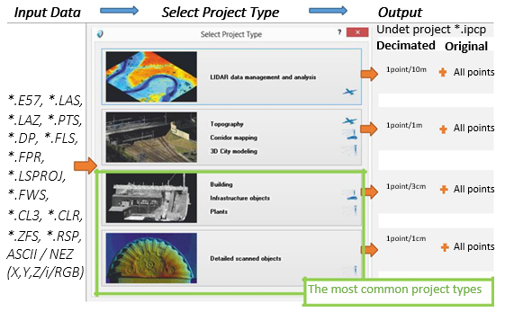
UNDET is hardware independent and allows to bring in numerous file types derived from various sources: airborne LiDAR, UAVs, drones, mobile mapping systems, terrestrial scanners, handheld scanners and photogrammetry. Undet does not have a registration module so your input data must be stitched together in your processing software prior bringing to UNDET.
Selecting a proper project type is an important first step :
Project type governs decimation level of your Point Cloud. Decimated Point Cloud is a lighter version of your original Point Cloud. Decimation is chosen once prior the Indexing and cannot be changed on the fly afterwards. In order to change it you must run the indexing again. Regardless, user can further control density of the decimated point cloud which at 100% for “Detail scanned objects” is 1 point every 1 cm.
On the other hand, the Original point cloud (All points) does not have density control. Decimated points switches to “All points” automatically in a smaller clipping area. The threshold that control this sits in the Density Settings.